Picture of the Kabul International Airport terminal and "gates."

More of KIA (Kabul International Airport).

Near KIA - the "mounds" of dirt are actually conical homes.

Kabul River running through town.

A fort or ruins on top of a hill in Kabul.

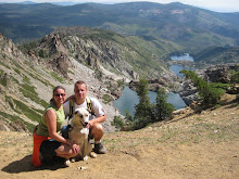
Dani, Gareth and Nova at FOB Airborne. (FOB = forward operating base) This is in Maiden Shahr.

Nova and Dani at FOB Airborne. Look at the beautiful hills in the background.

Picture of one of the large project sites in Wardak Province. This will be a National Logistics Training Center (NPTC) for the ANP. It's one of the ANP Program's flagship projects. The contract value is almost $100M.

Another view of the NPTC. This shows the foundation excavation.

Another view of the NPTC. This shows the foundation excavation with the perimeter wall.

A valley with lots of greenery and trees between Kabul and Maiden Shahr.

Here is a reservoir! There is a lot of water in Afghanistan but there is very little control of the water. So, a larger body of water like this is rare. Dani found it interesting that the height of the dam would imply the water level has been significantly higher than shown in this photo. For that to occur, the inundation area behind the dam would flood what appears to be populated areas.


No comments:
Post a Comment
Note: Only a member of this blog may post a comment.